2016年10月超強颱風海馬
Super Typhoon Haima in October 2016
2016年10月猛烈な台風22号(ハイマー)
超強颱風海馬(201622)在2016年10月下旬吹襲香港,是本年第二個讓香港天文台發出八號烈風或暴風信號的熱帶氣旋。這是香港天文台自1995年颱風斯寶吹襲香港以來,首次於10月發出的八號信號,亦是二戰後一年中第四最遲發出的八號信號。
10月中旬,海馬在關島以南海域形成,並逐漸增強為超強颱風。海馬在10月18日達到強度顛峰,中心十分鐘最高平均風速為每小時230公里。10月20日,海馬橫過呂宋島並進入南海,持續向廣東沿岸推進,強度稍為減弱。
從雷達影像可以看到,位於南海的颱風海馬發展出雙風眼結構(圖三)。颱風海馬在10月21日正午時分於廣東省汕尾市海豐縣鮜門鎮附近登陸,隨後在香港天文台東北偏東約110公里掠過。當晚,海馬進入內陸,並在10月22日早上在江西省境內減弱為低壓區。
海馬吹襲期間,香港多區出現烈風,離岸及高地間中吹暴風。由於香港東部離海馬眼牆的距離比西部更近一點,所以東部的風勢尤其強勁。氣壓方面,本氣象站在10月21日下午12時10分錄得最低平均海平面氣壓988.2hPa。
Super Typhoon Haima (201622) affected Hong Kong in late October 2016, which made itself become the second storm that caused the Hong Kong Observatory to issue Gale or Storm Wind Signal No. 8 in the year. This was also the first No.8 signal issued in October since Typhoon Sibyl in 1995; and the fourth latest No. 8 signal issued in a year after World War II.
Haima formed over the ocean at south of Guam in the middle of October. It gradually intensified into a super typhoon in the coming days. Haima reached its peak intensity on 18th October with a 10-minute sustained wind of 230km/h. Haima passed through Luzon Island and entered the South China Sea on 20th October. It then continuously moved towards the coast of Guangdong while its intensity gradually dropped.
The double eyewall structure of Haima could be observed in radar pictures (Picture 3). Typhoon Haima made its landfall at Houmen Town, Haifeng County, Shanwei City of Guangdong at around the noon of 21st October. Just a while later, it passed through the area that was about 110km east-northeast of the Hong Kong Observatory. That night, Haima further entered inland and wakened into a low pressure area at Jiangxi in the morning of 22nd October.
During the affected period, gale-force winds were observed in most of the places in Hong Kong, while winds were occasionally stormy offshore and on high grounds. Winds were particularly stronger in the eastern part than the western part of Hong Kong because the eastern area was closer to the eyewall of Haima. Regarding to the pressure, this weather station recorded a minimum mean sea level pressure of 988.2hPa at 12:10pm of 21st October.
台風22号(ハイマー)が2016年10月下旬に香港を影響しました。だから、これは本年に香港天文台に「八号烈風或暴風信号」を発令させます二つ目の台風でした。これも1995年台風15号の影響以来、初めて10月に発令される八号信号、その後第二次世界大戦から以来一年間に四番目遅い八号信号でした。
10月中旬、ハイマーがグアム島以南の海域で形成して、そしてだんだん猛烈な台風になっていました。ハイマーが10月18日に強さの頂上に達して、中心の10分の最高な平均風速は230km/hでした。10月20日、ハイマーがフィリピンのルソン島で通過して、南シナ海に進入しました。そして、ハイマーが広東省の海岸に進み続けました。でも、強さはだんだん下降していました。
レーダーイメージによりますと、南シナ海での台風ハイマーが二つの目の壁を発展しました(図三)。台風ハイマーが10月21日正午に広東省汕尾市海豊県鮜門鎮で上陸しました。その後、香港天文台の東北東に約110kmで至りました。その夜、ハイマーが内陸に進んで、そして翌日に江西省で低気圧に弱くなりました。
ハイマーの影響期間、香港多区に測定の風は大強風に達した間、沖合と高地で一時暴風に届きました。香港東部は台風眼の壁と近いから、この区域の風は西部のよりもっと強いでした。気圧について、本ウエザーステーションで測定された最低平均海面気圧は988.2hPaであり、測定時間は10月21日午後12時10分でした。
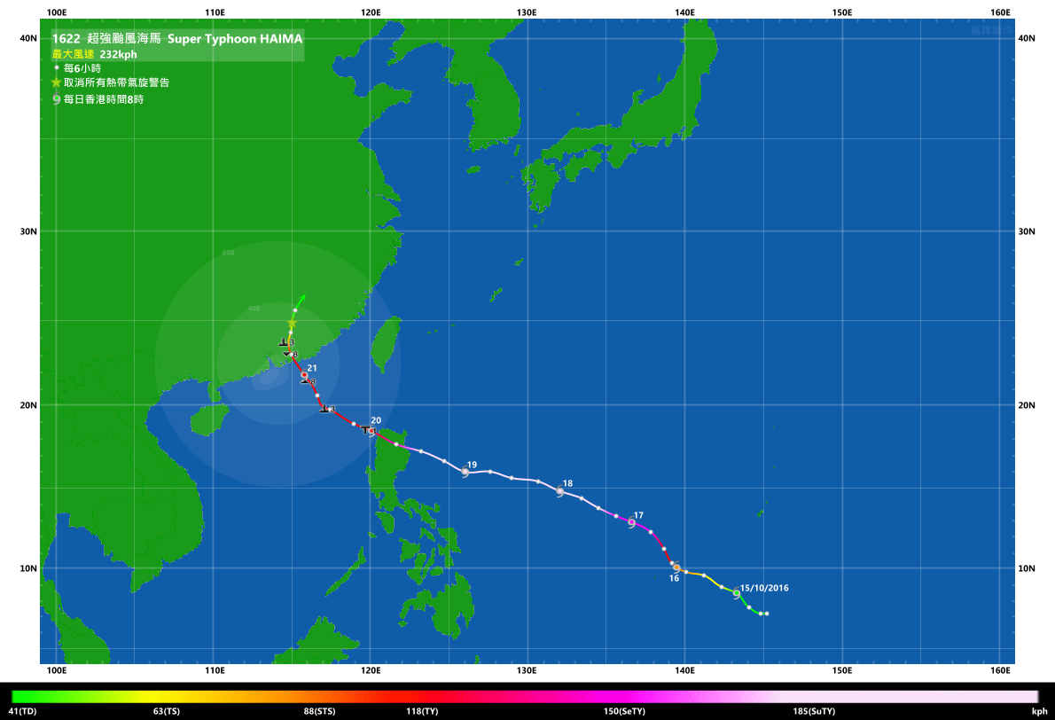
圖一:超強颱風海馬的全路徑圖
Picture 1: Full track of Super Typhoon Haima
図一:猛烈な台風ハイマーの全部経路

圖二:超強颱風海馬橫過香港附近時的路徑圖
Picture 2: Track of Super Typhoon Haima when it passed through the area near Hong Kong
図二:香港の付近を通過していた時、猛烈な台風ハイマーの経路

圖三:超強颱風海馬橫過香港附近時的雷達動畫
Picture 3: Radar animation of Super Typhoon Haima when it passed through the area near Hong Kong
図三:香港の付近を通過していた時、猛烈な台風ハイマーのレーダー動画