2016年8月颱風妮妲
Typhoon Nida in August 2016
2016年8月台風4号(ニーダ)
颱風妮妲(201604)在2016年8月影響香港,使香港天文台發出本年第一個八號烈風或暴風信號。連續6年有熱帶氣旋影響香港導致天文台發出八號熱帶氣旋警告信號,是自1981年以來首次。
7月29日,妮妲在菲律賓以東海域形成,隨後數天登陸呂宋東北部並進入南海。8月1日,妮妲增強為颱風,並加速向珠江口一帶迫進。作為權威數值模式的歐洲中期預報曾預測妮妲會登陸香港。最終,妮妲在2日凌晨在香港東北面境外的大鵬半島登陸,向西北偏西方向移動,橫過深圳,進入內陸並消散。
颱風妮妲正面吹襲香港,登陸後在香港天文台西北偏北約40公里處掠過。雖然如此,香港的風力並沒有預期中大,境內大部份地方只吹烈風,離岸及高地吹暴風。這是由於妮妲的風眼一直出現多個中心,阻礙風眼四周的颶風圍繞風眼旋轉。從風場圖中可見妮妲的暴風及颶風範圍集中在風眼的東面(圖一)。香港先受其西面眼牆影響,惟本地只吹起烈風。當風暴橫過深圳,香港開始受東面眼牆影響。可是,由於妮妲此時已開始受地形影響減弱,其東面的颶風也開始消失。最終香港全境沒有吹颶風。
颱風妮妲亦為香港帶來風暴潮。在天文大潮疊加影響下,尖鼻咀錄得最高潮位在3.6米左右,而風暴潮則為0.9米左右。氣壓方面,本氣象站在8月2日上午3時09分、3時20分和3時30分錄得最低平均海平面氣壓為983.0hPa。
Typhoon Nida(201604) affected Hong Kong in August 2016, which made the Hong Kong Observatory issue the first Gale or Storm Wind Signal No. 8 of the year. It was remarkable that the Observatory had issued the No. 8 Signal at least once in each year for the previous five years. Therefore, Nida made this year become the sixth year and this had not happened before since 1981.
On 29th July, Nida formed over the east of the Philippines. It landed on the north-eastern corner of Luzon and entered the South China Sea two days later. On 1st August, Nida intensified into a typhoon and accelerated as it approached the Pearl River Delta. ECMWF, as the world's top numerical weather prediction model, had once forecasted that Nida would land on Hong Kong. Eventually, Nida made its landfall on Dapeng Peninsula before dawn on 2nd August. It moved across Shenzhen and finally degenerated over the inner land of Guangxi Region.
Typhoon Nida gave a direct hit to Hong Kong. It was closest to the Observatory when it was about 40km to the north-northwest. However, winds were not as strong as expected. Most of the places in the territory were only affected by gale winds while winds occasionally reached storm force offshore and on high grounds. This was because there were several "centers" inside the eye of Nida, which avoided hurricane winds develop evenly around the eye. According to the WindSCAT picture, we could see that storm and hurricane winds only settled on the east of the eyewall (Picture 1). Hong Kong was affected by the west eyewall first, but only gale winds were recorded in the territory. Later on, when Nida landed and moved across Shenzhen, the east eyewall started to affect Hong Kong. During this period, as Nida began to weaken when it was on the land, the hurricane winds on the eastern part of the storm disappeared as well. Finally, no hurricane winds were observed in Hong Kong.
Typhoon Nida brought storm surge to Hong Kong as well. Under the combined influence of astronomical tide and storm surge, a maximum sea level of 3.6m was recored at Tsim Bei Tsui, while the net storm surge was 0.9m. Regarding to the pressure, this weather station recorded a minimum mean sea level pressure of 983.0hPa at 03:09am, 03:20am and 03:30am of 2nd August.
台風4号(ニーダ)が2016年8月に香港を影響しました。だから、香港天文台は本年の一つ目の「八号烈風或暴風信号」を発令しました。連続六年ある台風が香港天文台に第八信号を発令させましたことは、1981年以来の第一回でした。
7月29日、台風ニーダがフィリピンの東で発生しました。二日後、この台風がルソン島の東北で上陸しました。さらに、南シナ海に向いて動きました。8月1日、颶風の強度を達した台風ニーダが加速して珠江デルタに進み続けました。あの時、世界で権威の数値解析機関としてのヨーロッパ中期予報は一度、ニーダが香港で上陸することを予報しました。しかし、台風ニーダが2日の明け前に香港東北域外の大鵬半島で上陸しました。さらに、深圳を横断しました。最終、台風ニーダが広西自治区で消失しました。
台風ニーダが香港を直接的に襲いました。ニーダは北北西に約40kmで至った時は、香港天文台本部に最も近いでした。しかし、香港の風は予期より弱いでした。香港のほとんどの場所で測定の風は大強風だけに達した間、沖合と高地で一時暴風に届きました。これは、台風眼にセンターがたくさんあって、颶風は台風眼の周りで均等に発展できませんでした。WindSCAT写真によると、暴風と颶風の範囲が東側の壁で集中しました(図一)。香港は最初に、西の壁に影響されたけれども、大強風だけが測定されました。その後で、ニーダが深圳を横断していた時、香港は東の壁に影響されました。でも、この期間に台風ニーダがもう上陸したので、颶風が衰え始めました。最終、香港全域で颶風が測定できませんでした。
台風ニーダと関係がある高潮も香港を襲いました。天文潮と高潮は影響していた時、3.6メートルぐらいの最高潮位は尖鼻咀で測定して、高潮の潮位は0.9メートルくらいでした。気圧について、本ウエザーステーションで測定された最低平均海面気圧は983.0hPaであり、測定時間は8月2日午前3時09分、3時20分と3時30分でした。
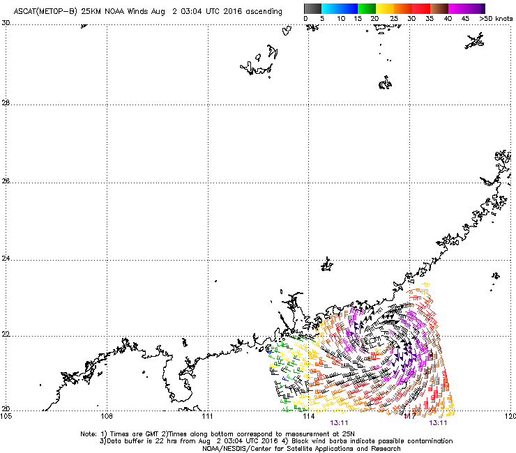
圖一:8月1日下午9時11分的風場分析圖,顯示暴風及颶風範圍集中在風暴的東南面。
Picture 1: WindSCAT picture at 9:11pm of 1st August showed that storm and hurricane winds mainly affected the southeastern side of Typhoon Nida.
図一:8月1日午後9時11分のWindSCAT写真は、暴風と颶風が台風の東南側に及んだ状況を表示しました。
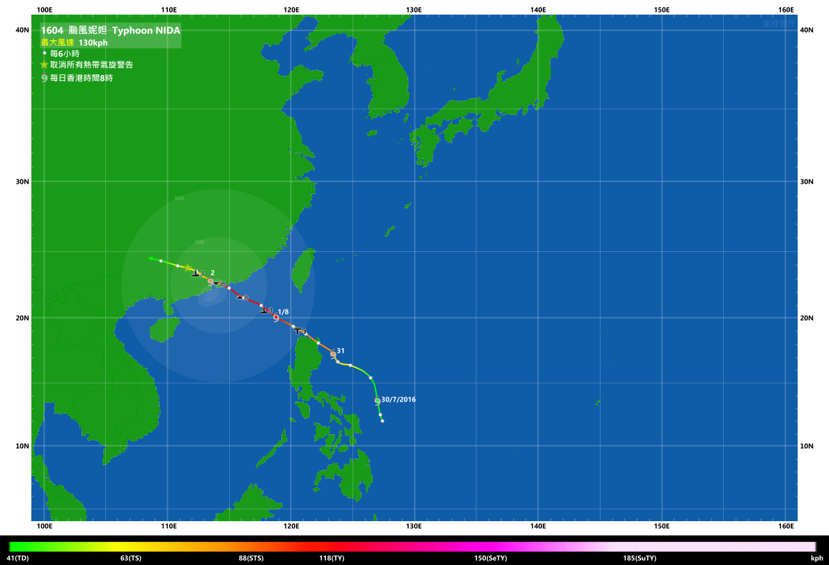
圖二:颱風妮妲的全路徑圖
Picture 2: Full track of Typhoon Nida
図二:台風ニーダの全部経路
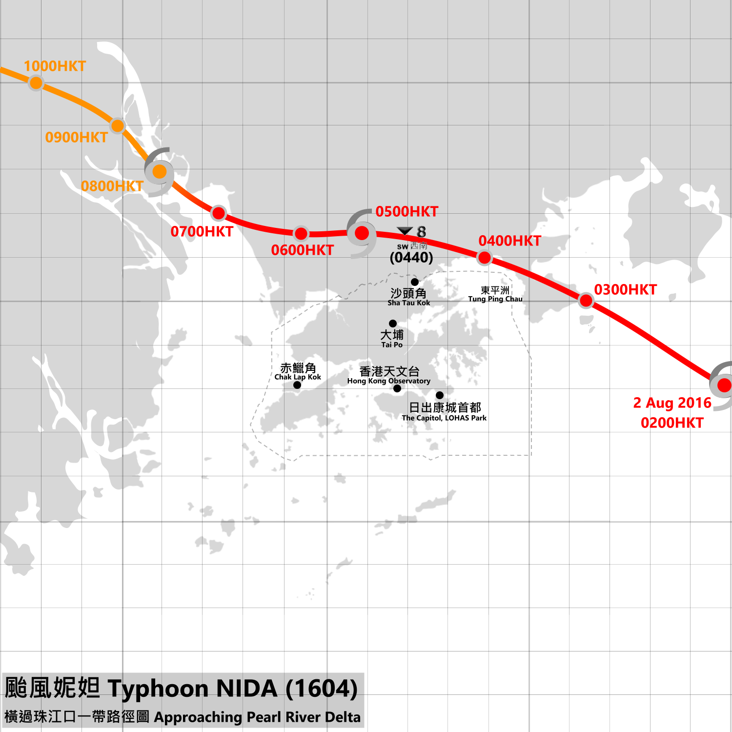
圖三:颱風妮妲橫過珠江口一帶時的路徑圖
Picture 3: Track of Typhoon Nida when it passed through the Pearl River Delta
図三:珠江デルタを通過していた時、台風ニーダの経路

圖四:颱風妮妲橫過珠江口一帶時的雷達動畫
Picture 4: Radar animation of Typhoon Nida when it passed through the Pearl River Delta
図四:珠江デルタを通過していた時、台風ニーダのレーダー動画